
March 29, 2024
Mains Daily Question
March 29, 2024
Q.3 Indian fisheries have witnessed a paradigm shift from marine dominated fisheries to inland fisheries. Explain. Mention the steps taken by the government to promote the fishery sector. (10M/150W)
|
Approach to the answer Understanding and structuring the answer: The question has 2 main parts – 1) reasons for decline in marine fisheries and 2) Government steps to promote fishery sector. Introduction: Type 1: Give a brief description about the share of inland and marine fisheries and make a graph as well. Type 2: Write about the importance of marine fisheries and show a declining trend of it. Body: Heading 1: Reasons for decline in share of Marine Fisheries – Divide it into two categories – Reasons for increase in inland fisheries and issues in Marine fisheries. Heading 2: Steps taken by the Government. Conclusion: Give a brief way forward. |
Answer:
India has a long coastline of about 7500 km which is crucial in making it the second largest producer of fishes in the world after China. Till 2000, marine fish production dominated India’s total fish production. However due to practice of science-based fisheries, Inland fisheries in India has seen a turnaround and presently contributes around 70 % of total fish production.
Reasons for transition:
The reasons can be grouped under two broad categories as follows:
- Reasons for increase in share of inland fisheries:
- Rich inland water resources are available in India which increases the inherent potential to act as major resources like rivers, ponds, lakes etc.
- High Population Density along major rivers gives an assured market for inland fisheries.
- The Crop-Fishery system, in which fishing is done on the crop field, is adopted by many farmers in Bihar and Bengal.
- Support from Government for both production and post-production including harvest under Pradhan Mantri Matsya Sampada Yojana.
- Reasons for decreasing Marine Fisheries share:
- Lack of Good Fishing grounds, due to lack of cold-warm current mixing along the Indian coast, unlike countries like Japan.
- Greater diversity of fishery resources in the tropical regions creates difficulty in commercialization.
- Limited scope for expansion due to over-exploitation in territorial waters.
- Economic vulnerability of the fishermen along the eastern coast, limits the exploitation of the potential of an otherwise wide continental shelf.
- Environmental destruction due to the use of bottom trawlers has disincentivized the marine fisheries.
- Disputes with neighboring states like Sri-Lanka also negatively impact marine fisheries.
Keeping in mind the importance of the fishery sector, the Government has initiated a blue revolution to promote fishery sector in India.
Steps taken by the Government
- Separate Department: Foreseeing the vast resource potential and possibilities of export in the fisheries sector, a separate Department of Fisheries is created under the Ministry of Fisheries, Animal Husbandry and Dairying.
- National Fisheries Policy, 2020: It aims at comprehensive development of the fisheries sector through appropriate interventions to address the critical gaps in the fishery sector.
- For example, it stressed the need to strengthen cooperative federalism to promote the fishery sector. A GST-like forum should be set up for this purpose.
- Pradhan Mantri Matsya Sampada Yojana: Under this initiative, a cluster-based approach is adopted to create fishery zones by developing forward-backward linkages.
- Fisheries and Aquaculture Infrastructure Development Fund: It envisages funding infrastructure projects in the fisheries sector with a corpus of Rs.7522.48 crore.
- Rural Infrastructure Development Fund: Government has permitted NABARD to extend RIDF loans for fisheries related infrastructure such as fishing harbors and riverine fisheries.
- Kisan Credit Card: KCC facility is extended to fish farmers to meet the working capital requirement of fisheries activities including aquaculture.
The fishery sector provides livelihood to about 16 million people at the primary level and almost twice the number along the value chain. There is a need to upgrade fishery infrastructure, provide better fishing vessels, quality checks to improve exports and facilitate creation of fisherman producer organizations.
Mains Daily Question
March 29, 2024
Q.2 Electric vehicles are a constructive disruption in the automobile industry. What are the factors of location for setting up manufacturing units of electric vehicles in India? (10M/150W)
|
Approach to the answer Understanding and structuring the answer: The question asks about the location factors of Electric Vehicle Manufacturing units. Introduction: Type 1: Give some data regarding the Electric Vehicles and state its importance. Type 2: Explain why EVs are a constructive disruption in the automobile industry. Body: Heading 1: Factors of location for EV Manufacturing. Conclusion: Give a small way forward to promote EV. |
Answer:
The government is pushing for electric mobility to address climate change and pollution, enhancing energy security and job creation. According to NITI Aayog, electric mobility can cut energy demand by 64% which translates into savings of Rs 3.9 lakh crores. The share of electric vehicles is rising throughout the globe. For example, more than 80% cars sold in Norway were electric in 2022. Investment in EV manufacturing is rising to meet the demand.
|
Benefits of e-vehicles |
- Lower running costs: The running cost of an electric vehicle is much lower than an equivalent petrol or diesel vehicle. Electric vehicles use electricity to charge their batteries instead of using fossil fuels like petrol or diesel.
- Low maintenance cost: Electric vehicles have very low maintenance costs because they don’t have as many moving parts as an internal combustion vehicle.
- Zero Tailpipe Emissions: Driving an electric vehicle can help you reduce your carbon footprint because there will be zero tailpipe emissions.
- Tax and financial benefits: Registration fees and road tax on purchasing electric vehicles are lesser than petrol or diesel vehicles.
|
Factors of location for Electric Vehicle Manufacturing |
- Raw Material: Lithium, Cobalt, Nickel etc. are required for EV manufacturing. India imports these minerals. Thus, locations near the port are suitable.
- For example, Kochi and Mumbai.
- Market: Urban centers where average daily driving distance is less than 100 km can provide a good market.
- For example, EV can travel approximately 300 km on one charge.
- Labour: EV manufacturing requires skilled and semi-skilled workforce.
- For example, Bangalore, Hyderabad and Ahmedabad have a large pool of skilled workforce which makes them potential sites for EV manufacturing.
- Government Policies: Subsidies and tax incentives are crucial to set up EVs manufacturing facilities.
- For example, several state governments are providing incentives to set up e-vehicle manufacturing units.
- Agglomeration effect: Existing Industrial regions can offer labor, credit and other forward-backward linkages.
- For example, Delhi-Gurgaon region.
- R&D: The EV/battery industry's R&D powers new technologies.
India has a unique opportunity to take up a leadership role in Electric Vehicles, emerge as a global manufacturer and become AatmaNirbhar in the EV sector. Renewable energy should be promoted along with increased spending on R&D on battery technology and hydrogen fuel cells to make India an EV hub.
Mains Daily Question
March 29, 2024
Q1. The revival of inland waterways in India is a new step towards balanced regional development. In this context, analyze the prospects and associated challenges of development of inland waterways in India. (10M/150W).
|
Approach to the answer Understanding and structuring the answer: The question has two main parts – 1) Prospects of inland waterways in India, 2) Challenges related to the development of inland waterways in India Introduction: Type 1: Mention about the present situation of Inland waterways in India Type 2: Mention about important waterways in India Body: Heading 1: Prospects of Inland waterways in India Heading 2: Challenges in developing Inland waterways Way forward: Mention about the measures which should be taken to boost the inland waterway transport in India and address the issues and challenges. |
Answer:
India has about 14,500 km of navigable waterways which consist of rivers, canals, backwaters, creeks, etc. About 55 million tonnes of cargo is being moved annually by Inland Water Transport (IWT), a fuel - efficient and environment -friendly mode. Its operations are currently restricted to a few stretches in the Ganga-Bhagirathi-Hooghly rivers , the Brahmaputra, the Barak river, etc.
|
Prospects of Inland waterways in India |
- Can help bring down Logistics Costs and increase Export- Logistics cost in India is around 13% of GDP, much higher than in other countries. Inland waterways, the cheapest mode can make Indian goods cost-effective and more competitive.
- Employment potential: As per National Transport development policy committee, every Rs 1 lakh investment would generate 33.6 persons of employment.
- Connectivity to the North-East region will be improved, which does not have very efficient connectivity due to its geographical position and rail/road transport passing through the ‘chicken neck.’ E.g., Brahmaputra NW-2, River Barak NW-1
- Connecting resource-rich regions: Waterways will enhance connectivity in states like Bihar, UP where industrial development is lagged despite being resources rich by bringing ease of doing business.
- Act East with northeast development through various initiatives including Inland navigation. India will have alternative connectivity to the northeast region via-
- Kaladan Multimodal project with Myanmar
- MoU with Bangladesh to use Chattogram and Mongla ports for movement of goods to and from India
- Unexplored transport system: In India, Inland Waterways account for only 0.4% of trade, which can be explored more.
|
Challenges in developing Inland Waterways |
- Infrastructure: Insufficient port and terminal facilities, navigation aids, and maintenance infrastructure hinder smooth waterway operations.
- Outdated Technology: The use of outdated vessels, equipment, and navigation systems limits efficiency and safety.
- Environmental Concerns: Developing waterways can impact aquatic ecosystems, leading to concerns about biodiversity loss, habitat destruction, and water pollution.
- Regulatory Complexity: Navigating through a complex regulatory framework involving multiple government agencies and varying laws can slow down development projects.
- Maintenance and Dredging: Frequent dredging is necessary to maintain proper water depth, but it's resource-intensive and can raise environmental concerns.
- Interstate Coordination: Many waterways traverse multiple states, necessitating effective coordination and agreements among states for seamless navigation.
- Investment Needs: Developing waterway infrastructure requires substantial financial investment, which can be a challenge to secure, especially given competing priorities.
|
Way forward |
- Proper and environment-friendly dredging of rivers and proper measures for year-around navigation
- Building new ports, and multimodal connectivity through Sagarmala Project.
- A proper river information system, digital GPS, and necessary infrastructure for night navigation
Policy measures for the participation of the private sector
March 28, 2024
Mains Daily Question
March 28, 2024
Q.2 The effective utilization of marine resources can drastically reduce human miseries. Do you agree? What are the challenges in effective utilization of marine resources? (10M/150W)
|
Approach Understanding and structuring the answer: The question has two parts – 1) utility of marine resources in reducing human miseries and 2) challenges in effective utilization. Introduction: Give a brief idea about the marine resources or Body: Heading 1: Effective Utilization of Marine resources. Heading 2: Challenges in effective utilisation of marine resources Conclusion: Write about the SDG goals and a small way forward. |
Answer:
Marine resources refers to the physical and biological resources of oceans and seas. Oceans cover around 70% of the earth’s surface. With rising population and depletion of terrestrial resources, effective utilisation of marine resources can provide a viable alternative to increase the resource base.
|
Effective Utilization of Marine Resources |
- Food Security: Marine resources like fish and seafood, are important sources of nutrition for many coastal communities. Effective utilization of these resources through sustainable fishing practices can help address food insecurity, providing a stable and nutritious food source, and reducing hunger and malnutrition.
- Economic Development: Industries such as commercial fishing, aquaculture, tourism rely on the effective utilization of marine resources, providing employment opportunities and income for coastal communities. This can alleviate poverty, improve livelihoods, and uplift the socio-economic conditions of individuals and communities.
- Health and Medicine: Marine organisms have been a rich source of bioactive compounds with potential medicinal applications. The effective exploration and utilization of marine resources can lead to the discovery of new drugs, treatments, and therapeutic compounds, addressing health challenges and reducing human suffering caused by diseases.
- Renewable Energy: Marine resources offer significant potential for renewable energy generation, such as offshore wind, tidal, and wave energy. By effectively harnessing these resources, we can reduce dependence on fossil fuels, mitigate climate change impacts, and contribute to clean and sustainable energy systems, improving access to energy and reducing environmental degradation.
- Climate Change Resilience: Marine ecosystems, such as coral reefs and mangroves, provide coastal protection from storms, erosion, and sea-level rise. Effectively managing and conserving these ecosystems can enhance coastal resilience, reduce the impacts of climate change on vulnerable communities, and help prevent the displacement and suffering of populations due to extreme weather events.
|
Challenges in effective utilisation of marine resources |
- Overexploitation: Unsustainable fishing practices can deplete fish stocks, harm marine ecosystems, and undermine long-term resource availability.
- For example, as per FAO, more than a third of the fish stocks around the world are being overfished.
- Lack of Information: The oceans remain unexplored mainly due to its vast size and lack of international cooperation.
- For example, according to UNEP, more than 80% of oceans are unexplored.
- Threat to ecosystem: Development projects, like building ports, may threaten critical hotspots like coral reefs and mangroves.
- Technological Development: Exploitation of marine resources from deep sea levels require
- For example, deep sea mining at present technological levels is not economically viable.
- Tensions between Nations: Exploitation of marine resources can fuel tensions between nations and threaten global peace and security.
- For example, South China sea dispute between China and neighbouring countries like Philippines, Indonesia etc.
Marine resources can play a major role in reducing human miseries and achievement of SDG 1,2,3 and 7. However, these resources should be sustainably used. Further, there should be a globally accepted framework to distribute marine resources in the high seas.
Mains Daily Question
March 28, 2024
Q3. From being net food importer in the 1960s, India has emerged as a net food exporter to the world. Provide reasons. (10M/150W)
|
Approach: Introduction: Provide data points to justify the question’s statement Body: Heading: Reasons for India's transition from a net food importer to a net food exporter Conclusion: Way ahead |
Answer:
Once heavily dependent on food imports and aid, India has remarkably transformed into a major agricultural exporter. Through sustained enhancements in irrigation, infrastructure, crop diversification, supportive policies and export promotion over decades, India became a leading agri-exporter. (In 2021-22, farm exports touched USD 50 billion, rising 19.92% driven by production gains, reforms and export growth.)
|
Crop |
Production in 1960-61 (million tonnes) |
Production in 2021-22 (million tonnes) |
|
Wheat |
10 |
106.84 |
|
Rice |
35 |
130.29 |
|
Reasons for India's transition from a net food importer to a net food exporter |
- Green Revolution: The Green Revolution, which started in the late 1960s, led to a significant increase in food grain production through the adoption of high-yielding variety seeds, chemical fertilisers, pesticides and better irrigation facilities.
- This technological upgrade in agriculture led to a significant increase in food grain production, turning India from a food-deficient nation into one with a surplus. Punjab, Haryana and western UP were the major beneficiaries.
- Increased Irrigation cover: Irrigation cover through projects like dams, canals etc., has been increased from 18% of cropped area in 1950-51 to 48% in recent times.
- This has lowered the dependency on monsoon and also, ensured water availability in drought-prone regions.
- Better Farming Techniques:
- Mechanisation of agriculture such as the use of tractors, power tillers, harvesters etc. improved farm productivity.
- Better agronomic practices and extension services have helped disseminate advanced techniques among farmers.
- This has enabled us to shift focus from traditional crops like cereals to high-value crops like fruits, vegetables, spices etc. which generate higher incomes.
- Crop Diversification: Indian agriculture has diversified from staple cereals to high-value commercial crops like cotton, jute, oilseeds, fruits, vegetables, dairy, poultry etc. in response to rising domestic and export demand.
- Government Policy Support: Government initiatives like subsidies on seeds, power and fertilisers, crop insurance, and minimum support prices have incentivised farmers and boosted production.
- Food Processing and Exports: Government schemes like PMKSY, SAMPADA, and Mega Food Parks have promoted food processing, value addition and exports.
Sustained productivity growth through technology, investments, diversification and supportive policies has enabled India's remarkable transition to a leading agricultural exporter. However, challenges like smallholdings, overdependence on rain, infrastructure gaps and income disparities persist. Further efforts on irrigation, market reforms, high-value crops and farmer welfare are imperative to maintain competitiveness.
Mains Daily Question
March 28, 2024
Q1. Ground water is a silent resource which impacts humans at multiple fronts. In this regard, discuss the reasons for its alarming decline. Also suggest measures to ensure its sustainability. (10M/ 150W)
|
Approach: Introduction: Explain groundwater, its share in water profile and brief importance. Body: Heading 1 : Reasons for alarming decline of groundwater. Heading 2 : Ensuring sustainability of groundwater. Conclusion: Stressing its impact in food security and sustainable development, conclude via SDG-6. |
Answer:
Groundwater is the water that seeps through aquifer rocks and soil and is stored below the ground. In India, groundwater accounts for about 40% of total water supply. Although invisible but it silently supports many activities like:
- Agriculture: It supports irrigated agriculture (approx. 90%) and food security
- Ecosystem: It replenishes lakes, rivers, and wetlands; and sustains plants, animals, and human lives.
- Drinking water: It provides drinking water to 50% of the global population.
- Industry: It is used in industrial processes where surface water is limited.
Reasons for alarming decline of groundwater:
- Overexploitation leading to land subsidence and saltwater intrusion into coastal aquifers; it is often poorly understood, undervalued, mismanaged, and even abused.
- Poor governance: It is not physically visible, making it difficult for the general population and decision-makers to connect with the challenges affecting this resource.
- Urbanization: Rapid urbanization and population growth have increased demand for groundwater for drinking water supply and industrial purposes. Cities like Chennai and Bangalore face groundwater depletion due to excessive urban expansion.
- Pollution: Surface water encroachment, scarcity, and pollution are easily visible. But there is hardly any visual evidence for groundwater facing the same challenges.
Eg: Arsenic contamination in West Bengal.
- Neglect by public, CSO, media: Groundwater education is a neglected area, appreciation of groundwater is not taught in elementary schools. Thus, behavioural change is necessary to understand existing issues.
Ensuring sustainability of groundwater:
- Aquifer mapping, real time monitoring of consumption, extraction and recharge. Government, media and civil society has important role in educating people about groundwater.
Eg: Maharashtra and Andhra Pradesh have introduced groundwater regulation acts to address over-extraction.
- Afforestation to increase residence time of rain water and rain-water harvesting techniques must be adopted for groundwater recharge.
- Aquifers and groundwater reservoirs often extend beyond political boundaries of countries/states, so international/inter-state cooperation is also necessary.
- Mihir Shah Committee (2016) proposed an effective groundwater governance structure:
- The Central Water Commission and the Central Ground Water Board (CGWB) should be
united under a national water framework for an integrated approach.
- Linking cropping patterns and crop intensity with groundwater availability.
- Effective implementation of government initiatives like National Project on Aquifer Management (NAQUIM), ‘Catch the Rain’ campaign and Atal Bhujal Yojana is required for sustainable management along with community participation.
Groundwater depletion poses a significant challenge to water security and consequently to food security and sustainable development in India. By ensuring sustainable groundwater management, India can contribute to achieving Sustainable Development Goal 6 (Clean Water and Sanitation) and safeguarding this vital resource for future generations.
March 27, 2024
Mains Daily Question
March 27, 2024
Q.2 One third of India’s coastline is vulnerable to erosion. In this context, discuss the factors that cause coastal erosion. Also, enumerate its impacts and highlight the measures taken by the government in this regard. (10M/150W)
|
Approach to the answer Understanding and Structuring the Answer: To answer this question effectively, we'll first discuss the factors that cause coastal erosion in India. Then, we'll enumerate the impacts of coastal erosion and highlight the measures taken by the government to address this issue. Introduction:
Body:
Conclusion:
|
Answer: Coastal erosion is the wearing away of land by action of waves, currents and wind. Coastal erosion is accompanied by the landward recession of the shoreline and loss of land area. Human activities like construction of coastal structures, beach sand mining, offshore dredging, etc., have also triggered coastal erosion.
- There are four main processes of coastal erosion. These are corrasion, abrasion, hydraulic action and attrition.
- The Ministry of Earth Science (MoES) recently informed that 34% of coastline is under varying degrees of erosion for the past 28 years. West Bengal is the worst hit with over 60% of its shoreline under erosion.
|
Factors causing coastal erosion: |
|
Natural |
Anthropogenic |
|
|
|
|
|
|
|
|
|
|
|
Impact of coastal erosion: |
- Ecological degradation: Nearly 60% of the world's coral reefs have significantly deteriorated, 50% of all mangroves have vanished, and half of all wetlands have disappeared.
- Loss of land: It is brought on by both accelerated rates of sea level rise and decreased sediment delivery by the rivers.
- Increasing Vulnerability of Population: The majority of people live within 100 kilometers of the coastline. Environmental deterioration occurs in certain coastal regions, and developing nations are particularly affected.
- Pollution: The quality of much of the world's freshwater is declining due to pollution from industry, agriculture, and urban areas.
- Depleted resources: Endemic coastal fish stocks are now just 10–30% of what they were thirty years ago due to overfishing.
|
Following measures have been taken to prevent coastal erosion in India: |
- Indian National Centre for Ocean Information Services (INCOIS) has carried out Coastal Vulnerability Index (CVI) mapping to assess implications of sea-level rise along the Indian coast.
- National Centre for Sustainable Coastal Management (NCSCM), Chennai to research in the area of CZM including coastal resources and environment.
- Integrated Coastal Zone Management Plan (ICZM) to ensure optimum sustainable use of coastal natural resources. ICZM plans aim to regulate coastal development, conserve coastal ecosystems, and reduce erosion risks.
- The Ministry of Earth Sciences, in its reply, highlighted that the 15th Finance Commission had suggested ‘Mitigation Measures to Prevent Erosion’ under National Disaster Mitigation Force (NDMF) and ‘Resettlement of Displaced People Affected by Erosion’ under National Disaster Response Force (NDRF).
- At present, the National Disaster Management Authority (NDMA) is preparing suitable norms for mitigation measures and developing a policy to deal with the extensive displacement of people from coastal areas.
Coastal erosion is a severe problem for maritime developing countries like India, and immediate attention needs to be given to combat coastal erosion effectively on a scientific basis for evolving suitable designs of coastal protective structures.
Mains Daily Question
March 27, 2024
Q.3 The issue of air pollution in Delhi is much more severe as compared to other metropolitan cities in India. What are the factors responsible for such a situation? Also, give suggestions to overcome this problem. (10M/150W).
|
Approach to the answer Understanding and Structuring the Answer: To answer this question effectively, we'll first discuss the factors responsible for the severe air pollution in Delhi compared to other metropolitan cities in India. Then, we'll provide suggestions to overcome this problem. Introduction:
Body:
Conclusion:
|
Answer: Rapid urbanization and industrialization have led to increased air pollution concerns in all major metropolitan cities. However, Delhi faces a more serious air pollution problem compared to the other metropolitan cities.
|
Factors Responsible for Severe Air Pollution in Delhi: |
- Vehicular Emissions: Delhi has a large number of vehicles, and their emissions are a major source of air pollution. The increasing number of diesel-powered vehicles and outdated vehicles with inadequate emission controls worsen the situation.
- Industrial Emissions: The concentration of industries in and around Delhi releases significant amounts of pollutants into the air, including particulate matter, nitrogen oxides, and volatile organic compounds.
- For instance, proximity of Delhi to industrial regions like Faridabad, Okhla and Noida.
- Construction and Dust: Ongoing construction activities in Delhi contribute to a substantial amount of dust, which becomes airborne and adds to the particulate matter pollution.
- Biomass Burning: Crop residue burning in nearby states, especially during the post-harvest season, adds to Delhi's pollution burden, contributing to elevated levels of particulate matter and other pollutants.
- For instance, burning of paddy crops and other crops in Punjab and Haryana during winter months
- Geographical Factors: Delhi's landlocked geographical location, coupled with temperature inversions during winters, leads to the trapping of pollutants close to the ground, resulting in the formation of the infamous "Delhi smog."
|
Suggestions to Overcome the Problem: |
- Improvement in Public Transport: Encouraging the use of public transport and promoting electric and cleaner vehicles can significantly reduce vehicular emissions.
- Strict Emission Norms and Enforcement: Enforcing stringent emission standards for vehicles and industries, along with regular monitoring and penalties for non-compliance, can help control pollution at the source.
- Promotion of Clean Energy: Encouraging the adoption of renewable energy sources and clean fuels can help reduce reliance on fossil fuels, decreasing pollution from power generation and transportation.
- Waste Management and Biomass Utilization: Proper waste management practices and incentivizing alternatives to crop residue burning can mitigate biomass-related air pollution.
- Afforestation and Green Spaces: Increasing green cover through afforestation and creating green spaces within the city can help absorb pollutants and improve air quality.
- Public Awareness and Behavior Change: Educating the public about the impact of air pollution and promoting behavior change, such as carpooling and reducing waste burning, can have a positive impact.
By adopting a comprehensive approach that involves multiple stakeholders, including the government, industries, citizens, and civil society, Delhi can effectively combat air pollution and create a healthier environment for its residents.
Mains Daily Question
March 27, 2024
Q.1 Explain the concept of "land subsidence" and its distinction from "landslides." Discuss the measures that can be implemented to address the impacts of land subsidence. (10M/150W)
|
Approach to the Answer: Understanding and structuring the answer: The question has three main headings: 1) land-subsidence 2) difference between land-subsidence and landslide 3) Solution to reduce the crisis. Introduction: Type 1: You can introduce by talking about the recent land-subsidence crisis in Joshimath or Type 2: Can also start with definition of land-subsidence. Body: Heading 1: Write about what is meant by the term land subsidence Heading 2: Differentiate between land subsidence and landslides in a tabular form Heading 3: Write about the different methods to reduce land subsidence crisis. Conclusion: Type 1: You can include recommendation by any committee/report in the form of way forward or Type 2: You can also mention the harmful effect of land subsidence and how to deal with it in brief. |
Answer:
The recent land subsidence crisis in the Joshimath town of Uttarakhand has caused panic among environmentalists not only in India but across the world. The subsidence increased the occurrence of structural fissures in households, necessitating the evacuation of inhabitants to state-operated aid facilities highlighting the extent of the crisis.
|
Land Subsidence |
Land subsidence is gradual settling or sudden sinking of the Earth’s surface due to removal or displacement of subsurface earth materials. Subsidence is often caused by the removal of water, oil, natural gas, or mineral resources out of the ground by pumping, fracking, or mining activities.
It can also be caused by natural events such as earthquakes, soil compaction, erosion and sinkhole formation. Subsidence can occur over very large areas such as whole states or small corners such as a person’s garden.
|
Difference between land subsidence and landslide: |
|
Land Subsidence |
Landslide |
|
1. Landslide refers to a downslope movement of earth materials (rock or soil) under the effect of gravity. |
|
2. Landslides encompass all categories of gravity related slope failures in earth materials. Its cause can be both natural or man-made. |
|
3.There is both vertical and horizontal movement involved. |
|
4. Landslides typically occur on steep slopes and can be triggered suddenly. |
|
Various solutions to reduce land subsidence crisis: |
- Deep soil mixing: It involves injecting stabilising agents deep into the ground to reinforce the soil and prevent land subsidence caused by soil compression.
- Artificial recharge: It involves injecting water into depleted aquifers to replenish them, thus reducing the need for excessive pumping and preventing further subsidence.
- Alternative construction techniques: Using alternative construction techniques such as lightweight building materials and foundation systems can help reduce the weight of buildings thus minimizing the risk of land subsidence.
- Ground improvement techniques: such as deep soil mixing and soil stabilisation can help reinforce weak or soft soils to enhance the stability of structures and prevent subsidence in cases where a mass of buildings is unavoidable.
- Planting trees: Planting trees on slopes can help to strengthen soil and can help stabilize a slope. Trees and other deep-rooted plants are particularly effective in holding the soil together.
- Control of drainage: It is essential to manage and maintain drainage systems in hilly areas because inadequate drainage can cause the land to sag. To move water away from slopes and prevent erosion, culverts or other drainage systems can be installed.
- Planning and zoning: With careful planning and zoning, structures can be kept away from areas that are prone to subsidence. This may require the declaration of some places as no-build zones or the adoption of unique construction methods in high-risk areas. This will help in mitigating the impacts of land subsidence.
In India, the main causes of subsidence are the unregulated pumping of groundwater and the rapid pace of urbanization. It is important for authorities to consider and implement measures to mitigate the risks of subsidence, which may include better planning and regulation of construction projects in the area, proper regulation of mining activities, early warning systems, disaster preparedness plans, and community-based disaster management initiatives.
March 26, 2024
Mains Daily Question
March 26, 2024
Q2. Explain the phenomenon of the El-Nino Southern Oscillation (ENSO) and highlight its impact on Indian monsoon and agriculture. (10M, 150W)
|
Approach to the Answer: Understanding and structuring the answer: The question has two main headings: 1) ENSO 2) Its impact on Indian monsoon and agriculture Introduction: Type 1: Start with writing the concept of El Nino-Southern Oscillation (ENSO) or Type 2: Mention some incidents ENSO’s effect in India Body: Heading 1: Mention different phases of El Nino-Southern Oscillation (ENSO) and briefly describe them Heading 2: Write the effect of ENSO on Indian monsoon and agriculture Conclusion: Type 1: Conclude with its importance on temperature and precipitation across globe |
Answer: El Nino Southern Oscillation (ENSO) is a recurring oceano-atmospheric condition in the Southern equatorial pacific due to change in the sea surface temperature. This alternating warming and cooling pattern, also known as the ENSO cycle, has a direct impact on rainfall distribution in the tropics and may have a significant impact on weather across the Indian subcontinent and other parts of the world.
So this combination of El Niño, La Niña, and the neutral state between the two opposite effects is called the El Niño Southern Oscillation (ENSO).
Different phases of El Nino-Southern Oscillation (ENSO):
- El Nino: El Nino is the warming of sea waters in the Central-east Equatorial Pacific that occurs every few years (Warm phase off the coast of Peru).
- During El Nino, surface temperatures in the equatorial Pacific rise which weakens the trade winds — east-west winds that blow near the Equator.
- Due to El Nino, warm western pacific mound created in normal years start receding back because of which warm water gets accumulated near eastern pacific ocean due to el nino current.
- It thus brings warm water from the western Pacific towards America.
- La Nina: La Nina is just the opposite of El Nino. It is the positive extreme of the walker cell. It sees cooler than average sea surface temperatures in the eastern equatorial Pacific region. Trade winds are stronger than usual, pushing warmer water towards Asia.
- Neutral (walker cell) : Neither El Nino nor La Nina.
- The Walker circulation (walker cell) is caused by the pressure gradient force that results from a high pressure system over the eastern Pacific ocean, and a low pressure system over Indonesia and nearby regions.
How ENSO impacts monsoon and agriculture in India?
- Monsoon:
- ENSO has a profound impact on summer monsoonal rainfall across India, as most major droughts occur during El Nino events.
- During La Nina events, above average rainfall is witnessed in the Indian sub-continent.
- Agricultural productivity:
- El Nino has a direct impact on India's agricultural sector since it tends to reduce the production of summer crops.
- For example, affected crops include rice, sugarcane, cotton, and oilseeds.
- Rainfall during La Nina events might result in farmers losing their standing Kharif crops.
- For example, while Kharif crop harvesting happens in September-end or early October, any rain immediately before that would be damaging to the standing crops.
|
Additional information:
|
ENSO is one of the most important climate phenomena on Earth due to its ability to change the global atmospheric circulation, which in turn influences temperature and precipitation across the globe. Because of ENSO, we can often predict the arrival of many seasons in advance of its strongest impacts on weather and climate.
Mains Daily Question
March 26, 2024
Q3. What do you understand by the term urban heat island? Explain its causes and suggest measures to mitigate its impact on Indian cities. (10M, 150W)
|
Approach to the Answer: Understanding and structuring the answer: There are two main parts of the body. One is about the causes of urban heat island and the other is about the measures to be taken to mitigate its impact. Introduction: Briefly define Urban Heat Island and make a figure on it to make your introduction more elaborative. You can mention some facts/data regarding it as well. Body: Mention causes and consequences of Urban Heat Islands and discuss mitigation measures supported by some data or report. Conclusion: Summarize the key points and emphasize the importance of adopting measures to mitigate the urban heat island effect for sustainable urban development. |
Answer: The urban heat island effect is the phenomenon where urban or metropolitan areas are significantly warmer than their surrounding rural areas due to human activities and the built environment.
Causes of Urban Heat Island:
- Concrete and Asphalt: These materials absorb more solar energy, retaining heat and raising temperatures. Example: Busy city streets heat up significantly during the day.
- Building Density: Compact structures limit wind flow and heat dissipation. Example: Skyscrapers in Manhattan creating warm microclimates.
- Lack of Vegetation: Green spaces provide shade and reduce temperature through evapotranspiration. Example: Removal of parks in urban development leads to increased heat.
- Waste Heat: Energy use in buildings, transport, and industry releases heat. Example: Heat generated by air conditioning units can warm surrounding areas.
- Air Pollution: Some particles in the air have the tendency to trap heat. Example: Smog in Los Angeles enhances the heat island effect.
Mitigation Measures:
- Green Roofs: Planting vegetation on rooftops can reduce heat absorption and cool the surrounding air through evapotranspiration.
- Urban Forestry: Increasing green spaces and planting more trees can provide shade and cool the environment.
- Reflective Materials: Using materials that reflect sunlight on roads and buildings can reduce the amount of heat absorbed.
- Improved Public Transport: Enhancing public transport can reduce vehicular emissions, mitigating waste heat and pollution.
- Energy-Efficient Buildings: Constructing buildings with better-insulated materials and energy-efficient systems can lower the amount of waste heat produced.
The urban heat island effect is a serious problem that can have a number of negative consequences. However, there are a number of measures that can be taken to mitigate the urban heat island effect. By taking these measures, we can help to make our cities more livable and sustainable.
Mains Daily Question
March 26, 2024
Q1. Why is India considered a subcontinent? What are the implications of the large latitudinal and longitudinal extent of India? (10M, 150W)
|
Approach to the Answer: Understanding and structuring the answer: The question consists of two main parts: 1) Why is India considered a subcontinent? and 2) What are the implications of the large latitudinal and longitudinal extent of India? Introduction: Start by explaining the term "subcontinent" and why India is classified as one. Mention its distinct geographical features and importance on the global stage. Body: Heading 1: Why is India considered a subcontinent?: Explain the reasons why India is referred to as a subcontinent. Heading 2: Implications of the large latitudinal and longitudinal extent of India: Discuss the impact of India's large latitudinal and longitudinal extent on its climate, length of day and night, time zone, and agricultural practices. Conclusion: Conclude the answer by summarizing the significance of India's status as a subcontinent and its implications on various aspects of the country's geography, climate, and way of life. |
Answer: A subcontinent is a large and distinct landmass that is part of a larger continent but is geographically separated from the main continental landmass by geographical features such as mountains, seas, or other natural boundaries. Subcontinents are typically characterized by their unique cultural, geological, and environmental features. The Indian subcontinent, consisting of India, Nepal, Bangladesh, Pakistan, Bhutan, Sri Lanka, and the Maldives.
|
The latitudinal extent of Mainland India from the north to south is 37°6′ N to 8°4′ N. The longitudinal extent of India from west to east is 68°7′ E to 97°25′ E. |
India classified as a subcontinent:
- Geographical Separation:
- As per plate tectonics, India is a separate plate that collided with the Eurasian plate, leading to the formation of Himalayas.
- India is physically separated from the rest of the Asian continent by natural barriers. The northern border is defined by the massive Himalayan mountain range, which acts as a natural boundary. To the south, India is surrounded by the Indian Ocean. This isolation has contributed to the development of a distinct landmass with unique features.
- Size and physiological diversity:
- India is one of the largest countries in the world by land area.
- It has a long land frontier of about 15,200 km and coastline of about 7516.6 km.
- A physiological diversity that can be observed only on continental scale is present in India. For Example, a long coastline, a large desert (Thar), highest mountain ranges, and large plains (India-Ganga-Brahmaputra plains).
- This diversity of geographical features has led to a wide variety of climates, ecosystems, and biodiversity.
- Cultural and Linguistic Diversity: India is home to a rich tapestry of cultures, languages, and traditions. The country's large size has allowed for the development of different regional cultures and languages, making it a salad bowl of diversity.
- India's historical significance, with its ancient roots and birthplace of major religions, along with its economic and political importance as a major global player, makes it a country of immense influence and impact on the world stage.
Implications of large latitudinal and longitudinal extent:
- Climatic diversity: Large latitudinal and longitudinal extents provide diversity in climatic conditions in India.
- The area south of Tropic of Cancer has a tropical climate as the sun's rays strike the Earth's surface nearly vertically at noon.
- The oceans on both sides of the peninsular landmass help moderate the temperature through land and sea breezes.
- Towards the north of the Tropic of Cancer, India experiences a subtropical climate because the Sun's rays strike relatively obliquely.
- Length of day and night: Regions closer to the equator experience more consistent day and night lengths, while areas farther away from the equator witness more pronounced changes with the seasons, affecting various aspects of daily life and activities.
- Time-zones: The eastern parts receive sunlight much earlier than the western parts, leading to variations in the timings of sunrise and sunset across the country. While a single time zone promotes national unity and coordination, it can also create challenges for people in regions where daylight hours differ significantly from their natural body clocks.
- Biodiversity: Different regions offer unique ecosystems, habitats, and species, contributing to the country's remarkable ecological diversity.
- Resource Diversity: India has immense diversity in terms of availability of resources.
- Chota Nagpur Plateau is rich in mineral resources.
- Gangetic Plains are very fertile and contribute greatly to agriculture.
- Himalayas are gifted with extensive grasslands, forests, and potential mineral deposits.
- Arid and semi-arid areas are endowed with excellent solar and wind power potential.
- Cultural and Linguistic Diversity: The large size of India accommodates various cultural traditions, languages, and customs. Different regions have their distinct identities, contributing to the country's cultural tapestry.
- Socio-economic Disparities: The vast expanse of India also gives rise to socio-economic disparities. While some regions prosper economically, others face challenges in development and access to resources.
Therefore, India is a subcontinent in itself with its unique geographical, historical, political and cultural characteristics.
March 22, 2024
Mains Daily Question
March 22, 2024
Q3. Explain the processes involved in soil formation. Also identify the active and passive factors affecting pedogenesis. (10M, 150W)
|
Approach: Introduction: Define and explain pedogenesis in brief. Body: Heading 1 : Processes involved in the soil formation. Heading 2 : Factors responsible for soil formation. Conclusion: Type-1 : Highlighting the threats to soil, make a case for its conservation. |
Answer:
Pedogenesis, or soil formation, is the study of the origin and formation of soil. It is a continuous process regulated by the effects of environment, time and geological history.
It involves biogeochemical processes that act to both create and destroy order within soils leading to development of layers, termed as soil horizons, distinguished by differences in color, structure, texture, and chemistry.
Processes involved in the soil formation:
Soil formation takes place through various stages like addition, losses, transformation and translocation which takes place through various processes like:
- Weathering: Climate factors variations such as temperature, moisture, frosts etc. disintegrates rocks, breakdown and decomposes the minerals. It includes physical weathering, chemical weathering and biological weathering.
- Decomposition and humification: Decomposition is the process of breakdown of plant derived materials into its simpler organic constituents which is accomplished by enzymes, earthworms, mites and other organisms. On the other hand, Humification is the breakdown of plant remains leading to the formation of different types of humus.
- Leaching: The soluble minerals are removed from the soil profile due to percolation of water from top of soil. Continuous leaching tends to impoverish the upper mineral horizon. This process helps in the formation of laterite soil.
- Translocation: The movement of minerals in solution or suspension from one horizon to another is referred as the translocation. The upper mineral horizon from where the components are carried is called Eluvial horizon and the lower horizon where these components are deposited are called Illuvial horizon.
- Podzolization: It is a complex process of formation of Podzol soil where dissolved organic minerals are accumulated.
- Calcification: Calcification involves the accumulation of calcium salts in the soil profile, while salinization is the process of accumulation of salts in the soil.
- Gleization: It is the process of formation of the clay soil or wetland soil due to poor drainage conditions.
Factors responsible for soil formation:
Active factors, whose influence over soil development, is directly observed. These include:
- Climate: Temperature and moisture affect the rate of weathering, organic decomposition and biological activity. The high rate of heat and humidity accelerates the microbial action, on the other hand colder and drier climate slows down these processes.
- Biosphere/Organism: Soil formation is influenced by organisms and microorganisms, burrowing insects, animals and humans as they add up to the soils.
Passive factors, as their effects are not immediately observed. They control how climate and organisms affect soil development and formation. These include:
- Parent material: Soil minerals are the basis of soil and they are produced from parent rocks through the process of weathering and other processes of natural disintegration. The type of parent rock and the conditions, under which it broke down, deeply influences the property of the soil.
- Topography/Relief: Topography and relief of a region affects the climatic conditions, which ultimately influences soil formation processes and its characteristics.
- Time: Young soils lose the characteristics of the parent material over time and acquire other features resulting from the addition of the organic matter and the activity of the organism. The most important feature of the soil is that they pass through a number of stages as they develop, resulting in a deep profile with many well-differentiated horizons.
Thus soil is a valuable resource developed and nurtured over ages. This calls for concerted efforts for soil conservation from the present day threats like excessive erosion, desertification, salinisation etc.
Mains Daily Question
March 22, 2024
Q2. Urban forestry has emerged as an innovative solution which balances development and conservation. Describing urban forestry, discuss its need and various potential benefits it offers.(10M, 150W)
|
Approach: Introduction: Define urban forestry and briefly explain it. Body: Heading 1 : Need for urban forestry Heading 2 : Potential benefits of urban forestry Conclusion: Type-1 : Highlight role of urban forestry to realize and implement Sustainable Development Goal 11 (Sustainable Cities and Communities) |
Answer:
Urban forestry refers to the art of planting and managing trees/forest resources in urban and peri- urban areas in order to avail physiological, economic, sociological and aesthetic benefits. It aims to enhance environmental quality and human well-being. In India, rapid urbanization has intensified the need for urban forestry to address urban heat island effect and air pollution, among other challenges.
Need for urban forestry:
- Mitigating Urban Heat Island Effect: Trees provide shade and evaporative cooling, reducing surface temperatures and mitigating the urban heat island effect. (e.g. Bengaluru, Delhi)
- Improving Air Quality: Trees act as natural air filters, removing pollutants such as particulate matter and carbon dioxide, thus improving air quality and public health. (e.g. Tackling Delhi smog)
- Enhancing Biodiversity: Urban forests serve as important habitats for diverse flora and fauna, contributing to urban biodiversity conservation and ecosystem resilience. (e.g. Tree city status of Hyderabad)
- Stormwater Management: Tree canopies intercept rainfall, reducing surface runoff and flooding, while their roots absorb excess water and stabilize soil, mitigating urban flooding. (e.g. Chennai, Ahmedabad)
- Promoting Mental Health and Well-being: Access to green spaces and urban forests has been linked to improved mental health outcomes, stress reduction, and overall well-being of urban residents. (e.g. Chandigarh as city beautiful for it’s green spaces)
- Act as Carbon Sinks: Helps counter increased greenhouse emissions.
Potential benefits of urban forestry:
- Climate Change Adaptation: Urban forests help cities adapt to climate change by providing shade, reducing energy consumption for cooling, and sequestering carbon dioxide, thereby mitigating greenhouse gas emissions.
- Economic Opportunities: Urban forestry creates employment opportunities in tree planting, maintenance, and green infrastructure development, while also enhancing property values and attracting investment. (e.g. Gurugram, Noida)
- Social Cohesion and Community Engagement: Urban forestry projects foster community participation and social cohesion by providing opportunities for volunteering, environmental education, and recreational activities.
- Sustainable Urban Development: Integrating trees and green spaces into urban planning promotes sustainable development by improving livability, reducing energy consumption, and enhancing the aesthetic appeal of cities. (e.g. Bhopal, Indore)
- Ecotourism and Cultural Heritage: Urban forests and green spaces serve as tourist attractions, offering opportunities for nature-based tourism, cultural events, and heritage conservation. (e.g. Urban gardens in Mysuru, Kochi)
Urban forestry presents a multifaceted solution to the environmental, social, and economic challenges faced by rapidly urbanizing cities in India. By prioritizing urban forestry initiatives, India can contribute to achieving Sustainable Development Goal 11 (Sustainable Cities and Communities), which aims to make cities inclusive, safe, resilient, and sustainable.
Mains Daily Question
March 22, 2024
Q1. Mangroves are crucial for coastal ecology and economy. Elaborate. Also discuss the factors behind alarming loss of mangrove cover in India.(10M, 150W)
|
Approach: Introduction: Define and describe mangrove ecosystems in brief. Body: Heading 1 : Significance of mangroves for coastal ecology Heading 2 : Significance of mangroves for coastal economy Heading 3 : Factors causing alarming loss of mangrove cover Conclusion: Emphasizing their critical salience for humanity, exhort for their conservation. |
Answer:
Mangroves, dense salt-tolerant forests found along tropical and subtropical coastlines. Covering approximately 4,740 square kilometers, they are a unique ecosystem which offer ecological as well as economic utility for coastal areas.
Significance of mangroves for coastal ecology
- Rich biodiversity: Mangroves provide a nutrient-rich breeding ground for numerous species that thrive above and below the waterline. E.g., famed Bengal tiger is found in Sundarbans which is a mangrove forest.
- Natural Coastal protection: The sturdy root systems of mangrove help form a natural barrier against violent storm surges and tsunami. They perform a protective role for communities at risk from coastal erosion and severe weather events.
- Carbon Sequestration: Mangroves are unparalleled in their capacity for carbon sequestration. E.g, They store 3-5 times more carbon in the equivalent area than tropical forest.
- Ecosystem services: Mangroves help to maintain water quality by the uptake of pollutants and cycling of nutrients.
Significance of mangroves for coastal economy
- Medicinal Value: Plant extracts are collected by locals for their medicinal qualities. E.g., Anti-bacterial traditional medicines.
- Livelihood support: The leaves of mangrove trees are often used for animal fodder. Mangroves are also a source for forest produce like wax, honey etc.
- The forest waters provide local fishermen with a rich supply of fish, crabs and shellfish to sell for income.
- For example, Nearly 80% of the global fish catch relies on mangrove forests.
- Promote ecotourism: As they are located near to coral reefs and sandy beaches, the forests provide a rich environment for activities like sports fishing, kayaking and birdwatching tours.
- Wood: Mangrove trees are a reliable source of wood for construction which is prized for its hardy resistance to rot and insects. The wood is also harvested commercially for pulp and charcoal.
As per researchers at IISc, India has lost 40% of its mangrove area in the last century.
Factors causing alarming loss of mangrove cover:
- Coastal Development: Rapid urbanization, industrialization, and infrastructure projects encroach upon mangrove areas, leading to habitat loss and fragmentation.
- Agriculture: Conversion to agriculture, such as biofuel plantations etc. is a major contributor to loss of mangroves.
- Nutrients, pesticides, and other toxic chemicals from agricultural runoff cause damage to mangroves.
- Pollution: Urban runoff, sewage, and industrial waste ends up in the mangroves polluting them.
- For example, Plastic and other solid wastes cause stress to mangroves by suffocating aerial roots and inhibiting new growth.
- Aquaculture expansion: Pressure from coastal fishing is causing depletion of mangroves.
- 38% of global mangrove loss has resulted from clearing for shrimp culture.
- Climate change: Mangroves are very sensitive to changes in oceanic surface properties and sea level rise, resulting from climate change.
Preserving India's mangrove ecosystems is essential for biodiversity conservation, climate change mitigation, and sustainable development. Awareness generation, regular monitoring, mangrove afforestation and livelihood support for communities
Living near mangroves can help reduce anthropogenic pressure on mangroves.
Further, collaboration with locals, coastal industries and global organizations like UNEP, Global Alliance for Mangroves should be effectively pursued.
March 21, 2024
Mains Daily Question
March 21, 2024
Q2. Discuss the factors that affect the vertical and horizontal distribution of temperature in the ocean. (10M, 150W)
|
Approach to the answer: Understanding the question: The question talks about the factors that are responsible for the distribution of temperature in the ocean vertically as well as horizontally. Here we need to explain the different factors that are responsible for the change in the distribution of the temperature. Introduction: We can introduce the question by explaining the role played by the temperature in the marine ecosystem. Also mention how variation in the temperature regulates global climate. Body: Since the directive is to discuss, explain the different parameters which are responsible for affecting the vertical and horizontal distribution of the temperature in the oceans. Here, we can make two parts each for vertical and horizontal distribution. Provide some examples, facts and also we can draw a map to show distribution of the temperature. Conclusion: Conclude the answer by mentioning the complexity of the temperature distribution and how understanding this helps us to understand the global climate and marine ecosystem. |
Answer:
The vertical and horizontal distribution of temperature in the ocean plays a crucial role in global climate, ocean circulation, and the health of marine ecosystems. Temperature is a major factor in determining the density of seawater, which in turn affects ocean circulation and the movement of nutrients and other materials. Variations in temperature can also create gradients that drive upwelling and downwelling, which help to regulate the global climate.
The vertical distribution of temperature in the ocean is affected by:
- Depth of the ocean: As the depth of the ocean increases, temperature decreases. This is because sunlight is unable to penetrate to the depths of the ocean and the pressure of the water column increases.
- Amount of mixing in the water column: Mixing in the water column is another factor that affects the vertical distribution of temperature. Vertical mixing brings deeper, colder waters to the surface, cooling the surface waters. This can be caused by winds, currents, or convection.
- Salinity of the water: Water with higher salinity has a higher density and is heavier. This causes it to sink and causes a cold layer at the bottom of the ocean.
The horizontal distribution of temperature in the ocean is affected by:
- Ocean currents: Warm currents carry warm water from the equator to higher latitude regions, while cold currents carry cold water from the poles to lower latitude regions.
- Winds: Winds can mix the surface layers of the ocean, bringing warm and cold water together, and thus redistributing the temperature.
- Air temperature: During the summer, air temperatures are generally warmer, which can cause the surface waters of the ocean to become warmer as well. Conversely, during the winter, air temperatures are generally colder, which can cause the surface waters of the ocean to become cooler.
- Unequal distribution of land and ocean water: In the northern hemisphere, the oceans tend to have a higher average temperature compared to the southern hemisphere. This temperature variation between the hemispheres is due to the unequal distribution of land and ocean water.
- Latitude: Temperature in the ocean generally decreases with increasing latitude.
The vertical and horizontal distribution of temperature in the ocean is highly variable and is affected by a variety of factors. These factors interact to create a complex pattern of temperature changes throughout the ocean. Understanding the patterns and factors that affect the temperature distribution of the ocean can help us better understand the ocean and its role in the global climate system.
Mains Daily Question
March 21, 2024
Q1. What are the factors that influence Ocean Currents? Discuss the impact of ocean currents on the fishing industry of the world. (10M, 150W)
|
Approach for the answer: Understanding and Structuring the Answer: The question has two main headings: 1) Factors influencing ocean currents & 2) Impact of ocean currents on the fishing industry. Introduction: Define Ocean currents. Body: Heading 1: Factors Influencing Ocean Currents Here, we will discuss the various factors that influence the formation and behavior of ocean currents. Heading 2: Impact of Ocean Currents on the Fishing Industry In this section, we will explore how ocean currents affect the fishing industry worldwide and the implications for fisheries and fish stocks. Conclusion: The conclusion will summarize the key points about ocean currents' significance in the context of the fishing industry. |
Answer:
Ocean currents, with their large-scale and continuous movements of seawater, are vital in shaping the Earth's climate and weather patterns. They also play a crucial role in distributing heat, nutrients, and marine life across the world's oceans.
Factors that influence Ocean Currents:
- Planetary Winds: The direction, strength, and duration of winds determine the direction and intensity of surface currents in the oceans.
- For instance, Trade winds push Equatorial currents westwards.
- Earth's rotation: The Earth's rotation causes bulging at the equator and flattening at the poles, resulting in a system known as thermohaline circulation. This circulation helps distribute heat from the equator to the poles, regulating the Earth's climate.
- Coriolis force: The Coriolis force influences the circulation of ocean currents, causing gyres to move clockwise in the northern hemisphere and counterclockwise in the southern hemisphere.
- Solar Heating: Solar heating causes water to expand, creating a gentle slope that encourages water flow.
- Temperature Difference: Temperature variations impact ocean currents, with warm water rising to the surface and moving towards the poles, while cold water sinks and moves towards the equator.
- Salinity Difference: Salinity, or salt concentration, plays a significant role in ocean currents. Evaporation increases water salinity, causing it to sink and generate deep ocean currents.
- For instance, high salinity areas can also create surface currents that move water towards regions with lower salinity.
- Geography: The shape of coastlines, presence of islands, and the configuration of landmasses influence the direction and strength of ocean currents.
- For example, currents may be deflected by underwater ridges or channeled through narrow straits.
Role of Ocean Currents in fishing industry of the world:
The role of ocean currents in the fishing industry worldwide is significant. These currents influence the distribution of nutrients and marine life, affecting fish abundance and locations in different areas. Some key impacts of ocean currents on the fishing industry are:
- Upwelling: Upwelling brings nutrient-rich water to the surface, supporting marine life and creating rich fishing grounds. Overall, coastal upwelling regions only cover 1 percent of the total area of the world’s oceans, but they provide about 50 percent of the fish harvest brought back to shore by the world’s fisheries
- For example, the region off the west coast of Peru undergoes continual coastal upwelling and is among the richest fishing grounds in the world..
- Migration patterns: Ocean currents affect the migration patterns of fish, influencing the timing and location of their journeys to spawning grounds, which can impact the fishing industry's catch.
- Fishing locations: Ocean currents determine where fish are found, with nutrient-rich areas like upwelling zones having more abundant fish populations.
- For instance, the Gulf Stream offers fertile fishing grounds for tuna and swordfish.
- Climate patterns: Ocean currents influence regional weather patterns, which can affect the fishing industry.
- For instance, changes in currents can lead to alterations in water temperature, impacting fish migration and abundance.
The forces that influence ocean currents play a crucial role in the global fishing industry. Wind, temperature, salinity, and Earth's rotation all affect the distribution of nutrients and marine life in oceans. Upwelling, migration patterns, fishing locations, and climate patterns are impacted by ocean currents, influencing the fishing industry's catch. Understanding these forces is vital for the industry's sustainability and success. Studying and monitoring these factors will enable us to manage and preserve ocean resources for future generations.
Mains Daily Question
March 21, 2024
Q3. Explain the phenomenon of the formation of tsunamis. The eastern coast of India is more vulnerable to tsunamis than the western coast. Give reasons. (10M, 150W)
|
Approach to the answer: Here, we need to explain the formation of tsunamis and then explain why the eastern coast of India is more vulnerable to the tsunamis as compared to the western coast.
Introduction: We can introduce the question by mentioning the reason for formation of tsunamis and adding some facts about tsunami formation.
Body: Since the directive is to explain, we need to comprehensively explain the process of the tsunami formation in the first part. In the second part of the answer, we need to explain why the eastern coast is more vulnerable to tsunamis as compared to the western coast of India. Here, we need to add some diagrams and maps along with examples.
Conclusion: We can conclude the answer by summarizing the tsunami impact on the coasts. |
Answer:
Tsunamis are large waves generated by sudden movements of the ocean floor that displace a large volume of water. These are usually associated with earthquakes. According to the Global Historical Tsunami Database, since 1900, over 80% of likely tsunamis were generated by earthquakes.
However, Tsunamis can also be triggered by other phenomena like submarine landslides and volcanic eruptions, or even due to the impact of meteorites and asteroids.
Formation of Tsunami:
A tsunami is a series of extremely long waves caused by a large and sudden displacement of the ocean, usually the result of an earthquake below or near the ocean floor. This force creates waves that radiate outward in all directions away from their source, sometimes crossing entire ocean basins.
Unlike wind-driven waves, which only travel through the topmost layer of the ocean, tsunamis move through the entire water column, from the ocean floor to the ocean surface.
Different kinds of events can produce a tsunami:
- Earthquake: Earthquakes are generated by movements along fault zones associated with plate boundaries, which can cause vertical movement of the seafloor and large areas of horizontal motion. Shallow focus earthquakes in subduction zones are responsible for the most destructive tsunamis, which are caused by the amount of vertical and horizontal motion of the seafloor, the area over which it occurs, and the efficiency with which energy is transferred from the earth's crust to the ocean water.
- Landslides: Resulting in rock falls, icefalls, or underwater (submarine) landslides or slumps can generate displacement of water to create a tsunami. More often than thought, submarine landslides are often caused by earthquakes, large and small, therefore strengthening the force of an earthquake induced tsunami.
- Volcanic eruption: Volcanic eruptions can generate powerful and destructive tsunamis, most commonly occurring around the "Ring of Fire" area in the Pacific Ocean. The most destructive tsunami on record was caused by the explosion and collapse of the volcano Krakatoa in Indonesia in 1883, killing over 36,000 people and destroying coastal towns and villages.
Eastern coast of India is more vulnerable to tsunamis than the western coast:
- Location: The eastern coast of India is more vulnerable to tsunamis due to its location near the edge of the Indian Ocean and its proximity to earthquake-prone areas such as the Circum-Pacific Belt.
- Closer to Sunda and Java trench: The eastern coast of India is located closer to the Sunda and Java trenches, which are two of the most active seismic zones in the world. These are the sources of many of the earthquakes that can produce tsunamis.
- Sumatra Subduction zone: The eastern coast of India is also located closer to the Sumatra subduction zone, which is the site of the 2004 Indian Ocean tsunami. Following the 2004 Sumatra–Andaman earthquake, a number of studies have pointed out that Sumatra–Andaman subduction zone is one of the world׳s most potential hazardous zones for triggering possible giant tsunami that can have a larger population exposure.
- Presence of bays and inlets: The coast is made up of a series of bays and inlets, which can cause the water to become more turbulent and cause a tsunami to travel faster and farther.
- Open water: The eastern coast of India is more exposed to open water, making it more vulnerable to tsunamis than the western coast. The western coast of India is more sheltered, which can help protect it from the destructive forces of a tsunami.
The eastern coast of India is more vulnerable to tsunamis than the western coast due to its proximity to the Indian Ocean and the Bay of Bengal and the presence of numerous islands and shallow waters. The western coast of India is protected by the Western Ghats, which helps shield it from the effects of tsunamis.
March 20, 2024
Mains Daily Question
March 20, 2024
Q.2 Explain how western disturbances impact the climate over the Indian subcontinent. (10M/150W)
|
Approach for the answer The question talks about the western disturbances and its impact on climatic conditions over Indian subcontinent. Here we need to explain what the western disturbances are and how they are responsible to bring different changes over the Indian subcontinent.
Introduction: We can introduce the question by defining western disturbances in short and their area of origin. Body: Since the directive is to explain how, we need to explain the impact of western disturbance on each component of the climate over Indian subcontinent along with some examples, facts, and must include the map showing western disturbance and its area of influence. Conclude: We can conclude the answer by mentioning the overall impact of the western disturbance on the climate |
Answer:
Western disturbances (WDs) are low-pressure weather systems that originate in the Mediterranean Sea and move eastward across the Middle East, Central Asia, and the Indian subcontinent. They are responsible for change in weather conditions over the Indian subcontinent.
Impact of the Western Disturbances over the climate of the Indian subcontinent:
Positive impacts:
- Rainfall: Western disturbances bring a significant amount of rainfall to the region, especially during winter. This rainfall helps to replenish the aquifers and reservoirs that are essential for agriculture. It also helps to reduce the risk of drought and water scarcity in the region.
- Reduction in air pollution: The rainfall from the western disturbances helps to reduce air pollution in the region. The moisture helps to capture pollutants such as dust and smoke particles, thus improving air quality.
- Moderate temperature: The moisture from the western disturbances helps to moderate the temperatures in the region, thus creating a more pleasant environment.
Negative impacts:
- Strong winds: The western disturbances often bring with them strong winds which can cause damage to infrastructure, especially in coastal areas.
- Heavy Rainfall: The rainfall from western disturbances can cause flooding in low-lying areas, resulting in property damage and loss of life.
- Disturbs human activities: The strong winds and heavy rain associated with western disturbances can cause disruption to transportation and communication networks.
- Storms and thunderstorms: These disturbances can also cause dust storms and thunderstorms, leading to reduced visibility and hazardous air quality.
Overall western disturbances have a significant impact on the climate over the Indian subcontinent, bringing much-needed rain and snowfall to some regions, affecting temperature and wind patterns, and contributing to the water supply of several important rivers.
Mains Daily Question
March 20, 2024
Q.3 Write the significance and challenges of the rising aerosols in the atmosphere. (10M/150W)
|
Approach to the answer The question talks about the rise in the aerosols in the atmosphere. Here in the first part, we need to write the significance of the aerosols in the atmosphere and in the second part mention the challenges of rising aerosols in the atmosphere. At the end we need to provide suggestions for the challenges.
Introduction: We can introduce the question by giving some facts and data regarding to the rising aerosols from some reports like IPCC.
Body: As the directive is to write, first we need to explain the significance of the aerosols with relevant facts and data. In the second part, write about the challenges of the rising aerosols with some examples to validate your points.
Conclusion: We can conclude the answer by giving some measures to tackle the rising aerosols in the atmosphere. |
Answer:
According to the IPCC report, the level of anthropogenic aerosols in the atmosphere is on the rise. Anthropogenic aerosol is a suspension of fine solid particles or liquid droplets in air created mostly by air pollutant like particulates and smoke emitted from vehicles, industries and other sources.
Significance of the aerosols in the atmosphere
- Cooling effect: Recent studies have found that aerosols can reduce temperatures by up to 0.5°C in some regions. This cooling effect can help to counterbalance the effects of global warming.
- Cloud formation: Aerosols can also act as cloud condensation nuclei, which can result in increased cloud formation. This increased cloud formation can help reflect more sunlight, which can in turn reduce temperatures even further.
- Reflection of UV rays: Aerosols can also help to reduce the amount of ultraviolet (UV) radiation that reaches the Earth’s surface thus reducing the risk of skin cancer and other health risks associated with excessive UV exposure.
- Air purification: By reflecting sunlight and acting as cloud condensation nuclei, aerosols can help to remove pollutants from the atmosphere. They can also help to reduce the formation of smog and ozone at ground level.
- Reduce forest fires: Aerosols can also help to reduce the risk of wildfires by reflecting sunlight. Aerosols can reduce the amount of heat that is present in the atmosphere, thus reducing the risk of wildfires.
Challenges of rising aerosols:
- Air Quality: Aerosols can reduce air quality and cause serious health problems, such as asthma, bronchitis, and heart disease, as well as reduced visibility, by increasing concentrations of pollutants such as ozone and nitrogen dioxide.
- For example, aerosols can act as “seeds” that help convert nitrogen oxides in the air into particulate matter.
- Climate change: The aerosols in the atmosphere can cause changes to the climate, resulting in extreme weather events such as heat waves, droughts, and floods.
- Reduced visibility: Aerosols can reduce visibility, making it difficult to see distant objects.
- For example: In India, studies have shown that aerosols can reduce visibility by up to 10 km.
- Acid rain: Aerosols can also contribute to acid rain, which can be damaging to plants, animals, and infrastructure.
- Ozone depletion: Aerosols can also contribute to ozone depletion, which can damage ecosystems and lead to increased skin cancer risk.
- For example: aerosols from South Asia are contributing to ozone depletion in the upper atmosphere.
- Loss of crop yields: Aerosols get deposited on the plants and reduce incoming solar radiation. This reduces photosynthesis and can also reduce crop yields, leading to food insecurity.
- For example: aerosols can reduce crop yields in India by up to 15%.
- Ocean acidification: Aerosols can also contribute to ocean acidification, which can have an adverse impact on marine ecosystems.
- For example: aerosols from South Asia are contributing to ocean acidification in the Indian Ocean (Nature Climate Change journal)
Overall, the rising levels of aerosols in the atmosphere have the potential to cause serious environmental and health consequences. It is therefore important to continue to monitor aerosol levels and to take steps to reduce pollution from sources such as vehicle emissions and agricultural practices.
Mains Daily Question
March 20, 2024
Q.1 What do you understand by the term Heat Budget of Earth? Discuss how human activities are having an impact on the Earth’s Heat Budget? (10M/150W)
|
Approach for the answer: Understanding the structuring of the answer: The question has two parts. In the first part you have to talk about the heat budget of the Earth and in the second part talk about how human activities are creating an impact on the Earth’s Heat Budget. Introduction: Type 1: Introduce the answer by discussing the concept of Heat Budget. Type 2: You can give some data regarding the Heat Budget. Body: Heading 1: Discuss in detail what constitutes the Heat Budget of the Earth with a neat labeled diagram. Heading 2: Discuss the impact of human activities on the Earth’s Heat Budget. Conclusion: Type 1: Conclude the answer by providing the need to maintain the heat budget. Type 2: Talk about what should be done to address the problems arising out of changes in the Heat Budget. |
Answer:
The earth receives a certain amount of Insolation (short waves) and gives back heat into space by terrestrial radiation (longwave radiation). Through this inflow and outflow of heat, the earth maintains a constant temperature and this phenomenon is referred to as the heat budget of the earth.
|
Heat Budget of the Earth |
To maintain a constant global average temperature, all of the sun’s radiation that enters Earth’s atmosphere must eventually be sent back to space. This is achieved through Earth’s energy balance.
Of all of the solar energy reaching the Earth:
- About 30% is reflected back into space from the atmosphere, clouds, and surface of the Earth.
- Around 20% of the energy is absorbed by the water vapor, clouds, and dust in the atmosphere, where it is converted into heat.
- Around 50% of the incoming solar radiation is absorbed by the land and ocean, and this energy heats up the Earth’s surface.
- The energy absorbed by the Earth returns to the atmosphere through three processes; conduction, radiation, and latent heat (phase change).
Thus, 70% of the sun’s energy is absorbed by the surface, clouds, and atmosphere causing warming.
Most of the energy emitted from the earth’s surface does not go directly out to space. This emitted energy is reabsorbed by clouds and by the gases in the atmosphere. Some is redistributed by convection, while even more energy is released into the atmosphere through condensation. The majority of the energy is absorbed by the greenhouse gases, methane, nitrous oxide, ozone, carbon dioxide and water vapor. These gases constantly emit the sun’s energy back into the atmosphere and keep the Earth at a habitable temperature. Eventually, most of the energy makes its way back out to space and Earth’s energy balance is sustained.
|
Impact of human activities on Heat Budget |
By maintaining a constant global average temperature, the heat budget helps in making the earth’s environment conducive to the survival of living organisms. But human activities have thrown the heat budget out of balance, leading to increasing temperature.
They are impacting Earth’s Heat budget by altering certain factors, like atmospheric aerosols, greenhouse gases, the planet's surface albedo, clouds, vegetation, land use patterns, and more.
- Greenhouse gases: The gases like CO2, Methane, water vapor, etc. emitted due to pollution traps more energy from going out in the form of long wave radiation and thus tends to increase the temperature of the earth.
- Albedo: Global warming which is a consequence of human activities is reducing the snow cover, thereby reducing the albedo of Earth. This tends to increase the heat absorbed by the planet.
- Aerosols: Atmospheric aerosols scatter incoming solar radiation, and a few aerosol types can also absorb solar radiation. Aerosols that mainly scatter solar radiation have a cooling effect. However, strongly absorbing aerosols have a warming effect.
- Evaporation and cloud cover: Rise in global temperatures result in more evaporation which leads to an increase in the water vapor in the atmosphere which traps the solar radiation. However, the formation of more clouds reflects back more of the solar radiation and thus gives a cooling effect.
- Other factors affecting the earth’s heat balance: Concretization of urban areas, change in land use patterns like roads, buildings, deforestation etc, impact heat budget. This is because clear ground has higher albedo and reflects back more radiation.
Earth’s heat budget has been altered towards warming, with the biggest contributor being increase in GHGs concentration in the atmosphere. Thus, there is a need for expediting mitigation measures promised under the Paris Climate Treaty.
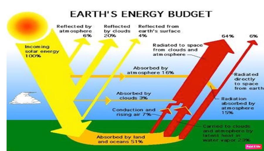
March 19, 2024
Mains Daily Question
March 19, 2024
Q2. Explain the impact of various jet streams on the the Indian Monsoon.(10M, 150W)
|
Approach to the answer Introduction: We can introduce the question by defining jet streams and how they play an important role in Indian monsoon. Body: We need to discuss the different types of jet streams and explain the impact of different jet streams on the Indian Monsoon. Conclusion: Conclude the answer by explaining the impact of climate change on the jet streams and also how it is affecting the Indian climate. |
Answer: Jet streams are fast flowing, narrow air currents found in the atmosphere. Jet streams play an important role in controlling global weather patterns, as they can transport energy and moisture from one place to another.
|
Additional information: You can use in your answer Impact of Jet Streams on the climatic conditions:
Various types of jet streams: Subtropical jet streams:
Easterly jet stream:
Somali jet stream:
|
Role of easterly jet stream in the Indian Monsoon:
- The easterly jet stream is one of the most important meteorological phenomena that influences the Indian monsoon. It is a narrow band of high-speed winds located near the equator.
- The jet stream originates in the Bay of Bengal and flows across India towards the Arabian Sea. This flow of air brings with it large amounts of moisture, which is then released as rain over the Indian subcontinent.
- The jet stream is an important factor in the formation of the monsoon, as it helps to create an area of low pressure over the Indian subcontinent. This low pressure draws in moist air from the Arabian Sea and Bay of Bengal, resulting in increased precipitation in the region.
- The jet stream is also responsible for the direction and speed of the monsoon winds, which helps to bring rains to different regions of India.
Role of Somali jet stream in Indian Monsoon:
- The Somali Jet Stream is a major atmospheric circulation feature that plays an important role in the formation and distribution of the Indian monsoon. The Somali Jet Stream is a semi-permanent westerly wind that originates over the Arabian Sea and moves eastward across India.
- As the jet stream moves eastward, it carries warm, moist air from the Indian Ocean, which increases the amount of moisture in the atmosphere over India. The increased moisture results in more precipitation, which is essential for the development of the Indian monsoon.
- The Somali Jet Stream also helps to create the low-pressure system that is necessary for the monsoon to form.
- In addition to this, the Somali Jet Stream helps to distribute monsoonal rainfall across India, allowing the monsoon to be experienced in many different parts of the country.
Climate change is causing the jet streams to become more erratic and intense. As the planet warms, the atmosphere is becoming more unstable, leading to a faster and more intense jet stream. This can lead to extreme weather events, such as more frequent and intense storms and floods, as well as more extreme droughts. In addition, the jet streams can cause shifts in weather patterns, leading to more frequent and intense heat waves and cold snaps in different regions.
Mains Daily Question
March 19, 2024
Q1. How are tropical cyclones formed? Explain the weather conditions associated with them. (15 Marks, 250 Words)
|
Approach for the answer: Understanding the structuring of the answer: The question has two parts and in the first part the question talks about the formation of tropical cyclones and in the second part it talks about the weather conditions associated with the tropical cyclones. Introduction: Type 1: We can introduce the question by giving the definition of cyclones. Type 2: You can also mention a few of their general characteristics. Body: Heading 1: First explain the formation of the tropical cyclones with a neat labeled diagram. Heading 2: Explain the weather conditions associated with them. Conclusion: Type 1: We can conclude the answer by mentioning the significant impact of the cyclones on the climate conditions. Type 2: Write about measures that can be used to deal with the impact of cyclones. |
Answer: Cyclones are rapid inward air circulation around a low-pressure area. The air circulates in an anticlockwise direction in the Northern hemisphere and clockwise in the Southern hemisphere.
A tropical cyclone is a rapidly rotating storm system characterized by a low-pressure center, a closed low-level atmospheric circulation, strong winds, and a spiral arrangement of thunderstorms that produce heavy rain.
|
Formation of Tropical cyclones: |
Tropical cyclones generally form over warm waters near the equator (sea surface with temperature higher than 27° C).
Formation and Initial Development Stage
- The process begins when warm, moist air from the ocean's surface rises, creating an area of low pressure. This causes air from the surrounding high-pressure areas to flow in and warm up, resulting in more air rising.
- It encourages formation of massive vertical cumulus clouds due to convection with condensation of rising air above the ocean surface.
Mature Stage
- When a tropical storm intensifies, the air rises in vigorous thunderstorms and tends to spread out horizontally at the tropopause level.
- At this stage, the spiraling winds create multiple convective cells with successive calm and violent regions.
- The regions with cumulonimbus cloud (rising limbs of convective cell) formation are called rain bands below which intense rainfall occurs.
- The winds continue to increase in speed, forming an eye in the center of the cyclone, where air pressure is at its lowest. The difference in temperature between the warm, rising air and the cooler environment causes the air to become buoyant and rise.
Modification and Decay
- A tropical cyclone begins to weaken in terms of its central low pressure, internal warmth and extremely high speeds, as soon as its source of warm moist air begins to ebb or is abruptly cut off.
- This happens after its landfall or when it passes over cold waters.
|
Weather conditions associated with the tropical cyclones: |
- Wind: Cyclones have gale force winds with wind gusts of more than 90 km/h around their center. These winds can cause extensive property damage and turn airborne debris into potentially lethal missiles.
- For example, the 2018 Cyclone Titli caused widespread destruction in India, with wind speeds of up to 140 km/h.
- Rain: Heavy rainfall associated with the passage of a tropical cyclone can produce extensive flooding.
- For example, the 2019 Cyclone Fani brought heavy rainfall and flooding to parts of India, particularly in the states of Odisha and West Bengal.
- Storm surge: A tropical cyclone can cause the sea to rise well above the highest tide levels of the year when it comes ashore. These storm surges are caused mainly by strong onshore winds and reduced atmospheric pressure.
- For example, the 2020 Cyclone Amphan caused a storm surge of up to 3 meters along the eastern coast of India, causing significant damage.
Tropical cyclones are powerful atmospheric systems that form over the different regions of the earth. They can cause significant destruction. With climate change and global warming their intensity and frequency are increasing across the world causing heavy loss of life and property.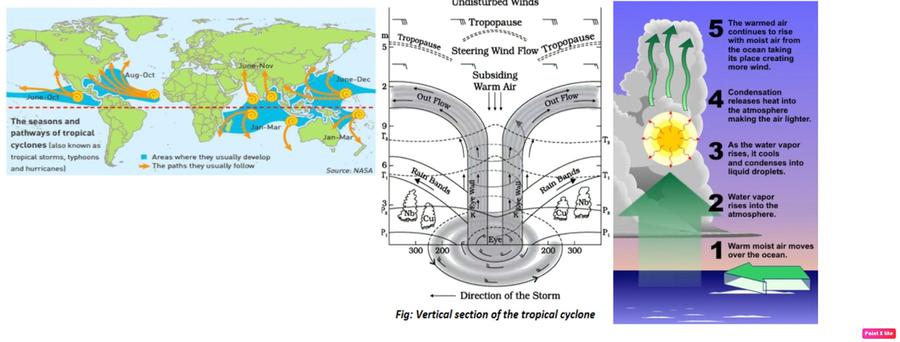
Mains Daily Question
March 19, 2024
Q3. With the recent pace and style of development, the cryosphere is facing an existential crisis. In this light, discuss the various threats faced by the cryosphere and also suggest possible solutions. (10M, 150W)
|
Approach: Introduction: Type-1: Define cryosphere discussion of its constituents. Type-2: Quote any recent report highlighting the issue. Body: Heading 1: Threats faced by the cryosphere. Heading 2: Solutions to contain the crisis. Conclusion: Type-1: SDG 13 focusing on climate action Type-2: Indian government initiatives |
Answer:
The cryosphere refers to the regions on Earth where water freezes into snow or ice.
IPCC observations show that there has been a continued net loss of ice from the cryosphere. According to the State of the Cryosphere 2023 report, nearly all tropical glaciers, most mid-latitude glaciers, and polar regions will disappear even if the world manages to limit global temperature rise to 2 degrees Celsius, above the preindustrial era.
Threats faced by the cryosphere:
- Melting Glaciers: Himalayan glaciers are receding rapidly, impacting water resources for millions. [e.g. Gangotri Glacier].
- Thinning Sea Ice: Arctic sea ice loss affects marine ecosystems and indigenous communities. [e.g.Chukchi Sea in Russia].
- Permafrost Thaw: Thawing permafrost in Ladakh leads to infrastructure instability and landslides. [e.g.Changthang Plateau].
- Ice Sheet Collapse: The retreat of Siachen Glacier poses security challenges and water scarcity risks. [e.g., Siachen Glacier].
- Glacier Lake Outburst Floods (GLOFs): GLOFs in Sikkim threaten lives, infrastructure, and agriculture downstream. [e.g., Lake Gurudongmar].
- Zombie ice phenomena: Dead or doomed ice that is attached to thicker areas of ice and is no longer getting replenished by parent glaciers. e.g. Greenland ice sheet.
Solutions to contain the crisis:
- Primary goal should be to limit the global warming within 2 degree Celsius from pre-industrial levels.
- Renewable Energy Adoption: Promote solar and wind energy to reduce reliance on fossil fuels. [e.g Solar farms in Ladakh]
- Sustainable Tourism Practices: Implement eco-friendly measures to reduce glacier tourism's ecological footprint. [e.g., Ecotourism in Himachal Pradesh]
- Climate Resilient Infrastructure: Construct resilient infrastructure to withstand permafrost thaw and GLOFs. [e.g. Bridge construction in Arunachal Pradesh]
- Afforestation Initiatives: Plant native species to stabilize slopes and mitigate glacial melt.
- Community Engagement: Involve local communities in glacier monitoring and adaptation planning. [e.g. Community-based projects in Sikkim]
- Resource Mobilization: Initiatives like Ambition on Melting Ice (AMI) COP27 should be adequately backed with financial commitments.
Protecting the cryosphere is essential to maintaining a stable climate and preserving the delicate balance of the Earth’s climate system. Urgent action is needed to mitigate cryospheric threats in India, aligning with Sustainable Development Goal 13 on climate action.
March 18, 2024
Mains Daily Question
March 18, 2024
Q.1 What do you understand by Sea Floor Spreading? Give an account of prominent evidence in its support.(10M, 150W)
|
Approach to the answer Understanding and structuring the answer: The question has 2 parts: 1) What is Sea floor spreading and 2) Prominent evidence in support of sea floor spreading. Additionally, add a diagram of seafloor spreading for better presentation. Introduction: Give a brief introduction about the sea floor spreading and explain the process in short. Body: Draw a diagram of seafloor spreading. Heading 1: Prominent Evidence in its Support: Write all the evidence in point format. Conclusion: Type1) Highlight the importance of theory of SeaFloor Spreading. Type2) write about how more research can help in even better understanding about the concept of seafloor spreading. |
Answer: Sea Floor Spreading theory was proposed by Professor Harry Hess in the 1960s. In the 1940s and 1950s, mapping of the ocean floor and paleomagnetic studies of rocks from oceanic regions revealed many facts which were used as prominent evidence in support of the theory of SeaFloor Spreading.
Seafloor Spreading
- The constant volcanic eruptions due to upwelling magma at the mid-oceanic ridges cause a rupture in the oceanic crust. The new lava wedges into it and thus pushes the oceanic crust on either side. This process is termed seafloor spreading.
- The seafloor is also destroyed in subduction zones, where oceanic crust slides under continents or other oceanic plates and sinks back into the mantle.
- Example, The East Pacific Rise is a site of major seafloor spreading in the Ring of Fire. It is located on the divergent boundary of the Pacific Plate, the Cocos Plate (west of Central America), the Nazca Plate (west of South America), the North-American Plate and the Antarctic Plate.
Prominent Evidence in its Support of seafloor spreading:
- Lava at the Mid Oceanic Ridges: It was observed that volcanic eruptions are common, and they bring huge amounts of lava to the surface. As molten material erupts from the mantle, it spreads out and pushes older rocks to the sides of the fissure, a new ocean floor forms along cracks in the ocean crust.
- Similarity in Rocks: The rocks equidistant on either side of the crest of mid-oceanic ridges show remarkable similarities in terms of period of formation, chemical compositions and magnetic properties.
- Paleo-magnetism: When molten rock cools and hardens, it aligns its magnetic field with the Earth's. However, if the molten rock is formed in a location separate from the existing seafloor, then its magnetic field will be opposite that of its surroundings. This creates an alternating pattern of magnetic stripes in the ocean crust. This was the first direct evidence for seafloor spreading.
- Age of Rocks: The ocean crust rocks are much younger than the continental rocks. Moreover, the age of the rocks increases as one moves away from the mid oceanic ridge. This means that new rocks are formed at the mid oceanic ridge.
- Depth of Earthquake: The deep trenches have deep-seated earthquake occurrences while in the mid-oceanic ridge areas, the quake foci have shallow depths. This means that upwelling of lava displaces the rocks on the surface of the ocean floor. Further, the ocean floor is forced to expand.
The theory of SeaFloor Spreading was an improvement over Wegener's Continental Drift theory. It paved the way for the development of new theories (like Plate tectonic theory) to explain the distribution of Oceans and Continents.
Mains Daily Question
March 18, 2024
Q3. Discussing the mechanism of festoon formation, explain the reason for their higher occurrence in the Indian and Pacific Ocean.(10M, 150W)
|
Approach: Introduction: Define festoons with examples to give context. Body: Heading 1 : Mechanism of festoon formation Heading 2 : Reasons for their higher occurrence in Indian & Pacific Ocean. Conclusion: Highlighting their tourism potential and threats faced by them, urge for conservation. |
Answer:
Festoons are islands arcs forming an archipelago in the shape of a loop around the edge of the mainland, marking the continuation of mountain ranges which can be traced on the continent, e.g. the East Indies, the Aleutian Islands, Ryukyu Islands etc.
They’re volcanic in origin formed at convergent tectonic plate boundaries, typically associated with subduction zones and volcanic activity.
Mechanism of Island Arc Formation:
- Subduction Zone: Oceanic crust subducts beneath another tectonic plate, generating magma that rises to form volcanic arcs. [ex- Marianas Trench]
- Magma Generation: Water and other volatiles released from the subducting slab melt overlying mantle, creating magma chambers. [ex- Aleutian Islands]
- Volcanic Activity: Magma rises through fractures in the overriding plate, erupting as volcanoes along the arc's curvature. [ex- Java Trench]
- Crustal Deformation: Compression and folding of the overriding plate contribute to the arc's curvature and island formation. [ex- Tonga Trench]
- Arc Migration: Island arcs may migrate over time due to changes in subduction angle or plate motion, altering their geological features. [ex- Philippine Sea Plate]
Higher Occurrence in Indian and Pacific Ocean:
- Subduction Zones: The Indian and Pacific Oceans feature numerous active subduction zones, providing ideal conditions for island arc formation. [e.g., Pacific Ring of Fire]
- Tectonic Activity: High levels of tectonic activity, including subduction and volcanic activity, characterize these ocean basins, promoting island arc development. [e.g Indonesian archipelago.
- Large Oceanic Plates: The presence of large oceanic plates facilitates long-lasting subduction and the formation of extensive island arcs. [e.g Pacific Plate]
- Hotspot Activity: Hotspots like the Hawaiian hotspot contribute to island arc formation in the Pacific Ocean through volcanic activity. [e.g Hawaiian Islands]
- Continental Fragmentation: Fragmentation of continental landmasses in the Indian and Pacific Oceans results in numerous small islands and island arcs. [e.g., Andaman Islands]
Festoons offer one of the best scenic beauty promoting the tourism economy and are home to the indigenous populations. They’re facing the threats of submergence due to increasing sea levels, hence global collaboration is needed to preserve them.
Mains Daily Question
March 18, 2024
Q.2 Explain the formation of the Himalayas with the help of theory of Plate Tectonics.(10M, 150W)
|
Approach to the Answer: Understanding and structuring the answer: The question requires an explanation of the formation of the Himalayas using the theory of Plate Tectonics. The answer should be well-structured and provide a clear understanding of the geological processes involved. Introduction: Start by briefly introducing the Himalayas as a prominent mountain range and mentioning its significance in the context of India's geography. Body: Heading: Formation of the Himalayas: Focus on the specific process of the Himalayas' formation. Explain that the Himalayas were formed due to the collision of the Indian Plate and the Eurasian Plate. Elaborate on how the Indian Plate was originally a separate landmass and drifted northwards over millions of years. Conclusion: Summarize or write about that the height of the himalayas are still increasing. |
Answer: The Himalayas are the world's highest and youngest mountain range, owe their origin to the theory of plate tectonics. This immense mountain range began to form between 40 and 50 million years ago, when two large landmasses, India and Eurasia, driven by plate movement, collided. The geological evolution of the Himalayas can be attributed to the movement and interaction of Earth's tectonic plates over millions of years.
|
Formation of the Himalayas with the help of the Theory of Plate Tectonics: |
- India’s landmass at 225 million years ago (Ma): During ancient times, India was a large landmass located off the Australian coast, separated from Asia by the vast Tethys Ocean.
- Northward-drifting at around 200 million years ago (Ma): The supercontinent Pangea began to break apart, and India initiated a northward drift towards Asia.
- Oceanic-continental convergence at around 80 million years ago: India was situated about 6,400 km south of the Asian continent and moving towards it at a rate of 9 to 16 cm per year. The Tethys Ocean floor was being subducted northward beneath Asia, leading to a convergent oceanic-continental plate boundary, much like the present-day Andes.
- Scraping of Sediments and formation of accretionary wedge: As India approached Asia, not all of the Tethys Ocean floor was completely subducted. Thick sediments on the Indian margin of the ocean were scraped off and accreted onto the Eurasian continent, forming an accretionary wedge.
- Birth of the Himalayas: These scraped-off sediments, along with the Indian continental plate, began to thrust upwards, giving rise to the Himalayas, the world's highest mountain range.
- Continental-continental convergence boundary at around 50–40 million years ago (Ma): India's northward drift slowed to about 4-6 cm per year, signifying the beginning of the collision between the Indian and Eurasian continental plates. This collision closed the Tethys Ocean and initiated the uplift of the Himalayas.
- Thickening of Continental Crust: Due to the low density and high buoyancy of both continental plates, subduction was avoided. Instead, compressional forces folded and faulted the continental crust, leading to the thickening of the crust in the region of the Himalayas and the Tibetan Plateau.
- End of Volcanic Activity: The thickening of the continental crust brought an end to volcanic activity in the region, as any magma moving upwards would solidify before reaching the surface.
The Himalayas are still rising by more than 1 cm per year as India continues to move northwards into Asia, which explains the occurrence of shallow focus earthquakes in the region today. However, the forces of weathering and erosion are lowering the Himalayas at about the same rate.
March 15, 2024
Mains Daily Question
March 15, 2024
Q.3 Discuss and differentiate the types of earthquake waves produced on the earth. What is the reason for the emergence of shadow zones?(10M, 150W)
|
Approach: Introduction: Type-1 : Define earthquake waves, discussing their features in brief. Type-2 : Body: Heading 1 : Different types of earthquake waves. Heading 2 : Emergence of shadow zone. Conclusion: Type-1 : Mention utility of this concept in understanding interior of the earth. |
Answer: Earthquake waves, also called seismic waves, are the vibrations generated due to shifting of rocks during an earthquake which travel within earth or along its surface. They are of various types depending upon the medium of travel, velocity etc.
Different types of earthquake waves: They’re of two types- body waves and surface waves. Body waves are generated due to the release of energy at the focus and move in all directions traveling through the body of the earth.
Body waves are of two types:
- P-waves: They are the first to arrive at the surface. They travel through gaseous, liquid and solid materials. P-waves vibrate parallel to the direction of the wave.
- S-waves: They arrive at the surface with some time lag. S-waves can travel only through solid materials. The direction of vibrations of S-waves is perpendicular to the wave direction in the vertical plane. Hence, they create troughs and crests in the material through which they pass.
When body waves interact with the surface rocks, they generate a new set of waves called surface waves. These waves move along the surface. They cause displacement of rocks, and hence, the collapse of structures occurs. Surface waves are of two types:
- Love waves: They have a particle motion, which, like the S-wave, is transverse to the direction of propagation but with no vertical motion. Their side-to-side motion causes the ground to twist from side to side.
- Rayleigh waves: They create a rolling, up and down motion with an elliptical and forward and backward motion in the direction that the wave is moving.
Emergence of shadow zone:
- Earthquake waves are recorded using seismographs located at far off locations. Shadow zones are specific regions where the waves are not reported.
- It was observed that seismographs located at any distance within 105° from the epicenter, recorded the arrival of both P and S-waves.
- However, those located beyond 145° from the epicenter, record the arrival of only p-waves. This is because p waves can travel through all mediums while S waves travel only via solids.
- P waves are refracted by the liquid outer core and are not detected between 105° and 145°
- Since earth’s outer core is liquid, S waves don’t travel and hence have a larger shadow zone (not detected beyond 105°).
- Thus, a zone between 105° and 145° from epicenter was identified as the shadow zone for both the types of waves.
Conclusive reason for the emergence of the shadow zone is the internal structure of the earth which is not homogeneous. Thus, the concept of the shadow zone has helped seismologists get information about the interior of the earth’s surface.
Mains Daily Question
March 15, 2024
Q.2 What do you understand by paleomagnetism? How does paleomagnetism support the theory of plate tectonics? (10M).
|
Approach to the Answer: Understanding and structuring the answer: The question has two main parts: 1) the concept of paleomagnetism and 2) how it supports plate tectonics theory. Introduction: Type 1: Write a brief introduction about paleomagnetism. Type 2: You can directly start by explaining the Paleomagnetism in introduction Body: Heading 1: Write details about paleomagnetism Heading 2: Discuss how paleomagnetism supports the plate tectonics theory Conclusion: Type 1: Conclude how this geophysical phenomenon helps in better understanding of the Earth or Type 2: You can write how the understanding about this phenomenon can be used in times to come. |
Answer: Paleomagnetism or fossil magnetism is an important source of our knowledge about the earth’s evolution throughout the entire geological history. This record is preserved by many rocks from the time of their formation. The paleomagnetic data provides decisive evidence for continental drift and plate tectonics theories.
|
Meaning of Paleomagnetism |
Paleomagnetism is the study of the ancient magnetic field recorded in rocks and sediments. When rocks form, certain magnetic minerals, such as magnetite, align themselves with the Earth's magnetic field, preserving the direction and intensity of the field at that time. By analyzing the magnetic properties of rocks, scientists can determine the past positions of the Earth's magnetic poles and the movement of tectonic plates over geological time.
Paleomagnetism provides crucial support to the theory of plate tectonics, which proposes that the Earth's lithosphere is divided into large, rigid plates that move over the semi-fluid asthenosphere.
|
Paleomagnetism supports plate tectonics theory in the following ways: |
- Polar Wandering: Paleomagnetic data from rocks of different ages and locations reveal a phenomenon known as apparent polar wandering. This is the apparent movement of the magnetic poles relative to the continents. The data shows that the positions of the magnetic poles have shifted over time and aligned with the movement of continents. This provides strong evidence for the idea of continental drift and plate movement.
- Seafloor spreading and the movement of tectonic plates: Paleomagnetic rocks on both sides of the mid-oceanic ridge show evidence of seafloor spreading. Magma rising from the ridges formed new rocks with an updated magnetic field alignment and pushed older rocks with outdated magnetic records away from the ridge.
- For example, a paleomagnetic study reveals that India's Deccan Lava Trap began to form when Madagascar and India were almost next to each other in the Southern Hemisphere.
- Paleomagnetic data as evidence for Continental Drift and for historical Reconstructions of plate boundaries: By comparing paleomagnetic data from different continents, scientists can piece together the history of plate movements and continental drift.
- For example, the orientation of magnetic minerals along the eastern coast of South America closely matches that of similar minerals on the western coast of Africa, which supports the idea that South America and Africa were once joined together as a single land mass.
Paleomagnetism is a powerful tool that provides crucial evidence for the theory of plate tectonics. The study of ancient magnetic fields recorded in rocks helps us understand the movement of tectonic plates, the shifting positions of continents, and the dynamic nature of the Earth's lithosphere over geological time.
Mains Daily Question
March 15, 2024
Q.1 Bring out various direct and indirect evidence that assist in understanding the nature of the Earth’s interior structure.(10M, 150W)
|
Approach to the Answer: Understanding and structuring the answer: The question has two main headings: 1) direct source of information about Earth’s interior and 2) indirect source of information. Introduction: Type 1: Write a brief introduction regarding the interior of the Earth or Type 2: Start with writing the significance of understanding the interior of the earth. Body: Heading 1: Write about direct sources of information related to the interior of earth. Heading 2: Mention indirect sources of information for earth’s interior. Conclusion: Type 1: Conclude by writing the importance of these discoveries or Type 2: You can also mention any recent deep drilling or mining news/report. |
Answer: The structure of the Earth's interior is basically the result of enormous and complex processes taking place inside the Earth. The origin of many phenomena like earthquakes, volcanoes, tsunami etc. are linked with the structure of earth’s interior. There are two primary sources of information about the internal composition of the Earth: direct evidence and indirect evidence.
|
Direct sources of information about the interior of earth: |
- Deep earth mining: In mining activity, minerals are extracted from deep below the surface.
- For example, gold mines in South Africa are as deep as 3 - 4 km. This gives a direct clue on changing density and composition of rock inside earth.
- Volcanic eruption: Volcanoes deliver information by the means of molten magma that comes out of Earth’s interiors.
- For example, volcanic eruptions in Hawaii island and mid-ocean ridges provide valuable insight into the chemical structure and temporal evolution of Earth's interior.
- Deep ocean drilling: Deep Ocean drilling project reveals vast information through analysis of materials collected at different depth.
- For example, the deepest drill in the Arctic Ocean (Kola) provides information about temperature maps for the Earth's interior, discovery of biological activity in the rocks, Conrad discontinuity etc.
|
Indirect sources of information about earth’s interior: |
- Temperature and pressure patterns: An increase in temperature and pressure with depth means an increase in density as well. Hence it becomes possible to determine the rate of change of characteristics of material on earth.
- Meteors: They have material and structure like earth and give information about the materials of which earth is formed of.
- Gravitational force(g): The gravitational force(g) is greater near the poles and less at the equator. Gravitational anomalies give us information about the distribution of mass of the material in the crust of the earth.
- Seismic activity: Earthquakes generate different types of waves (Primary and secondary waves) which suggest properties of different layers of the earth.
Human life is largely influenced by the physiography of the earth. Therefore, it is necessary that one gets acquainted with the forces that influence landscape development. To understand why the earth shakes or how a tsunami wave is generated, it is necessary that we know certain details of the interior of the earth.